June 18, 2020
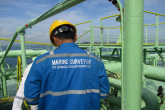
Hydrographic Surveyor

The exciting part of this career path is that you spend time working out in the field, so if you like outdoors this is a good career choice. As a hydrographic Surveyor you should be prepared to work in adverse weather conditions and spend extensive time out on boats managing heavy measuring equipment. An extra tip would be to ensure exposure to GIS systems. The information collected by the Hydrographic Surveyor can be particularly helpful to a salvage team when tasked with lifting or retrieving vessels or structures from the seafloor.
To pursue this career, you must be prepared to collect data on survey vessels and transform them into hydrographic models, which can be used for a wide variety of purposes. Most Hydrographic Surveyors use techniques like multibeam sonar and light detection to perform their jobs more accurately than ever.
Key tasks:
• Measuring and mapping the world’s underwater surfaces and studying the morphology (construction) of the seabed.
• The production of charts and related information for navigation.
• Dredging.
• Locating offshore resources (oil, gas, aggregates).
• Planning dock installation
Entry requirements/training:
To pursue this career choice, you must enrol at a TVET to obtain a National Certificate Hydrographic Surveying at NQF Level 4. As a candidate you must display proficiency in Mathematics, Communication and English, or have several years relevant hydrographic survey experience. You can also take a graduate degree with geography, hydrogeology, geophysics, and any other subject that might be related to these three.
Career advancement:
To evolve as a hydrographic surveyor, note that an undergraduate degree is the minimum qualification that is accepted. You need to advance and find better career opportunities as a senior surveyor by pursuing either a Masters or a Doctorate in the subject.
Associated job opportunities:
Professionals with expertise in hydrographic surveying can find associated job opportunities across different sectors. Here are some potential roles and associated job opportunities related to hydrographic surveying:
• Hydrographic Survey Technician
• GIS Specialist (Hydrographic)
• Data Analyst (Hydrographic)
• Marine Cartographer
• GIS Manager (Marine)